At this time, we believe there is not enough information to fully understand the collective traffic safety impact of these project proposals, although we can anticipate some of the impacts of individual projects which are included. If the plans incorporate best practices in regard to safety and safe mobility when implemented, some of these projects could have a real positive impact; if not, they could lead to the same types of high-speed, auto-centric, sprawl-inducing infrastructure that have made Austin’s traffic so dangerous in the first place.
In this post we will try to inform voters about the Mobility Bond, and spark discussion on how it could be used for safer mobility. While there are too many unknowns to assess the overall traffic safety impacts of the bond projects, there are societal benefits that could come from these projects, particularly in terms of job creation, transportation system capacity, and local accessibility. At Vision Zero ATX, we support efforts by the City of Austin to invest in traffic safety impact assessment and to incorporate best practices for safe mobility in these major projects. Regardless of the outcome of this bond election, Austin needs to spend significant resources on changing our road infrastructure if we are serious about achieving zero deaths on our roadways.
What the bond addresses:
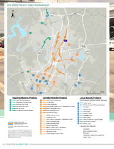
The Mobility Bond, if approved, would provide $720 million in funding for some new and some reconstructed transportation infrastructure in Austin. It would fund reconstruction of several major roadways, and fund study and design phases for several more. Several of the roads on the study list are dangerous south Austin corridors which haven’t received as much attention in corridor planning as similar roads elsewhere in the city. In addition, the bond would provide funding for some of the highest prioritized pedestrian and bicycle infrastructure needs outlined in the Sidewalk (map on p. 15), Bicycle (map on p. 15), and Urban Trails (map at end, page E-2) Master Plans. There are also smaller amounts of funding included for a few local road and intersection infrastructure projects.
|
|
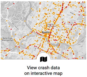
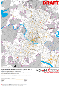
On the left map, you can see where the major projects in this plan are located. Compare those locations to the map of crash density in Austin on the right (click either map to open full documents in a new tab). Many corridors experiencing significant numbers of fatalities and serious injuries are addressed by the bond in some regard: most of these roadways north of the river have developed corridor plans, while most high-injury corridors south of the river still need to go through the planning process. Outside of what is included in the bond, future improvements will be needed on other roads including Pleasant Valley, East Seventh, South First, Manor Road, Parmer, Oltorf, and others.
What the bond doesn’t address:
- The Mobility Bond will not fund the non-infrastructure investments necessary for safer transportation, including social services, land use, traffic safety education, and enforcement tools. These other pieces, necessary for safer traffic, will still require funding from elsewhere.
- Many of the deadliest roads in Austin, such as our major highways and frontage roads, won’t be directly impacted except where they intersect with the projects in the plan. The included projects are mostly modifications to City of Austin-maintained roadways and road rights-of-way. TxDOT is a primary player that must buy into the safe mobility vision if Austin’s road network is to become safer for all road users.
- This bond is designed to provide a relative geographic ‘balance,’ and isn’t entirely focused on the areas that most need safe mobility investments. Traffic safety and safe mobility issues are experienced unevenly across neighborhoods and across different demographic groups. If reducing fatalities is a main priority, it doesn’t make sense for investments to be distributed in such a manner (even if that solution is perversely seen as a political balance).
- The bond funding is not enough to cover the costs estimated for all changes recommended in the completed corridor plans. This means that the modifications will have to be prioritized, and it is not yet clear which components would be funded and which would require additional funding outside this bond. In theory, the prioritized pieces will need to follow the City’s Vision Zero policy, but clarification of priority and process is needed.
Pieces of the Plan
Each component of the bond would lead to different outcomes for traffic safety and safe mobility options. Our thoughts on these impacts are outlined below:
Top Crash Intersections (“Vision Zero” piece) – $15m
This is funding to explicitly reduce fatalities on a few of the intersections determined to be the most dangerous. Supporting this piece is a no-brainer for us, as long as the engineers incorporate best practices in intersection design to slow vehicles, reduce travel conflicts, and give people walking, biking, and using mobility devices safe, accessible, and comfortable space away from vehicles.
Active Transportation – $111m
These funds would build accessible sidewalks, trails, safe street crossings, and bicycle infrastructure. Such facilities as they currently exist in Austin are mainly limited to the central core. The investments in active transportation infrastructure would bring a high return-on-investment in the ability of residents to safely get around their own neighborhoods by providing protected infrastructure where people can travel apart from vehicles. In particular, protected bike infrastructure that modifies existing city streets has been shown to increase safety for all road users.
The funding intended for sidewalks is split between (1) high priority sidewalk needs identified in the Sidewalk Master Plan, targeted to neighborhoods that are poised to use them and that can most benefit from new infrastructure investments, and (2) an even distribution of sidewalk funding across City Council districts known as “Safe Routes to Schools” funding. Given the high number of people who are killed and hurt in Austin while crossing dangerous streets, these loosely defined “Safe Routes to Schools” funds could achieve some of the greatest traffic safety benefits through construction of new, safe pedestrian crossings and traffic calming mechanisms along dangerous, high-speed roadways.
Corridor Plans – $482m
These corridor plans address several roadways which are currently some of the most dangerous in Austin, such as Lamar Boulevard, Airport Boulevard, and Slaughter Lane. In theory, there are a number of improvements that could greatly improve these corridors for the safety of all road users, such as:
- slowing top speeds of vehicles through lower design speeds and traffic calming measures;
- increasing safe crossings;
- increasing safe mobility options (read: buses and transit infrastructure);
- adding protected bicycle lanes;
- reducing commercial driveways;
- adding medians with tree plantings; and
- reducing traffic conflicts through smarter intersection design and signal connectivity.
While some of these concepts are incorporated into the corridor plans, and should be implemented ASAP, the plans are largely geared toward increasing vehicular capacity and throughput. This focus won’t relieve congestion for anyone for long, could encourage greater sprawl, and could cause these areas to experience even more carnage. The City of Austin has adopted several policies that call for greater safety and accessibility such as the Vision Zero and Complete Streets policies since the existing corridor plans were written, so there is an opportunity for the safety components in the corridor plans to be strengthened prior to construction.
Regional Mobility – $101m
The regional mobility projects are called regional as they are intended to make it easier for people around the metro area to cross Austin. These major road and bridge reconstructions would increase the vehicular capacity of those roads – although due to the effect of induced demand would be unlikely to significantly affect congestion or driving time for the average driver. If they are successful, they will continue to encourage sprawl in and outside of the city limits, which is typically associated with more driving overall and more severe crashes.
These regional mobility projects would increase accessibility in certain ways, but they would also encourage additional driving and higher vehicle speeds – both things which are associated with more traffic injuries and death. Relying on a sparse network of large high-speed highways rather than a slower, more interconnected road grid is the type of historical infrastructure decision that has lead to Austin, and Texas generally, being one of the most dangerous places in terms of traffic safety in the developed world.
Other Local Mobility – $11m
There is additional funding for bringing several local streets “up to code.” There are multiple guides that traffic engineers use to define being up-to-code and following best practices. Without implementation details for these local mobility projects, it is hard for us to assess the overall traffic safety implications of these projects.
In conclusion
Transportation infrastructure planning involves a consideration and balance for the safety of all road users, but also regard for the impacts on congestion, the environment, the local economy, physical activity, public safety, and other concerns. We would prefer safety and safe accessibility be the primary focus of these plans. If funded, we believe it is vital that changes in safety and accessibility at each of these project locations be openly assessed so the community can make sure these funds are well-spent, and can learn for use in future infrastructure projects.
Hopefully this primer provides information for you as a voter to understand the traffic safety implications of Prop 1 and make an informed decision as you head into the ballot box.
More information and perspectives on the Mobility Bond
- City of Austin Mobility Bond information page
- Austin EcoNetwork’s Civics 101 – Transportation and Prop 1
- KUT’s coverage of Prop 1’s impact on traffic safety
- League of Women Voters’ voter guide in English (p. 39), y en español (p. 46)
- Reddit AMA – 2016 Mobility Bond (2016 Prop 1) – hosted by @atxfriends & @AURAatx
Pro-prop 1
Anti-prop 1